
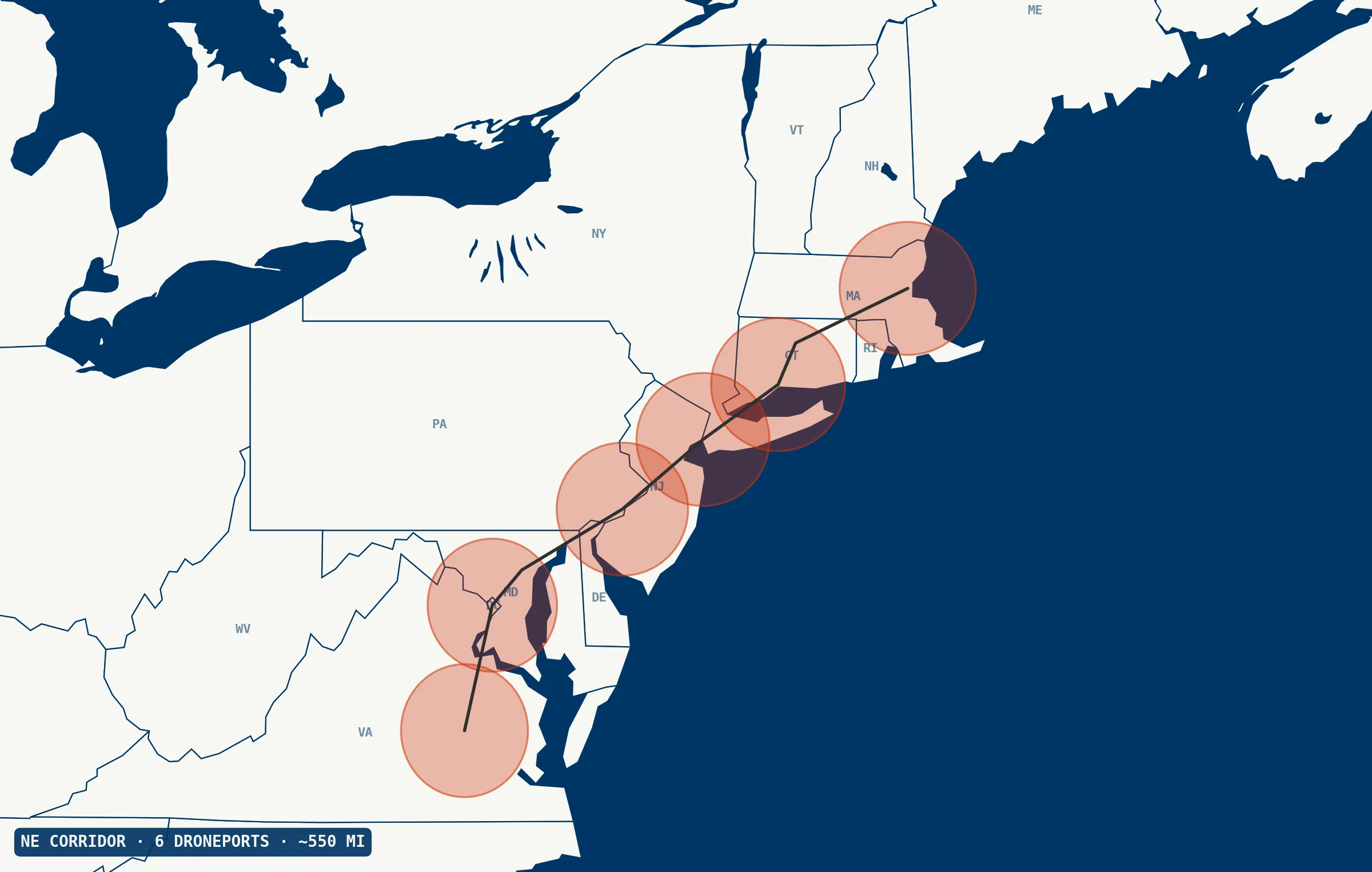
Transmission and rail rights-of-way, swept corridor-scale.
Helicopter-grade sensor coverage without the crew or scheduling window. A networked Droneforce™ fleet, integrated with your outage-response workflow.
What the helicopter does. Without the helicopter.
Transmission corridors run hundreds of miles. Range meets the corridor; payload makes the sweep worth making.
On rail corridors Track geometry and rail flaw detection require on-rail contact, so aerial complements rather than replaces them. The same platform adds value for ROW vegetation, post-incident rapid assessment, bridge and culvert inspection, and washout-risk monitoring in mountainous terrain.
Post-storm damage assessment, where utilities survey hundreds of miles in a few days and helicopter fleets are overwhelmed. Wildfire-risk vegetation management in California and the West, where PSPS (Public Safety Power Shutoff) schedules reward routine corridor sweep. Today, that combination means a flight crew, an aircraft, and a scheduling window. A networked Droneforce™ fleet is flexible, integrated with your outage-response workflow, an extension of your operations center, and either autonomous or operator-directed — your call.
The full corridor stack, every sortie.
The full corridor-inspection sensor stack on one airframe, simultaneously. Standard commercial drones fly one of these at a time. Manned aircraft carry the whole stack, but crew availability gates the revisit cadence. The Droneforce™ 55 runs the whole sweep unmanned, on demand.
Across corridor-scale inspection.
- vs. helicopters Autonomous corridor sweep — no crew, no aircraft scheduling.
- vs. ground patrols Orders of magnitude faster over long corridors; no truck rolls.
- vs. short-range inspection drones Corridor sweep, not tower-by-tower. Different job.
- vs. fixed-wing LiDAR survey Same corridor, routine revisit — not once every few years.
Full-stack corridor data, streamed live.
Data from a networked Droneforce™ fleet, integrated with the systems you already run — keyed to the assets you already manage, delivered into the tools your operations team already uses.
RGB, thermal, corona/UV, and LiDAR data across the corridor — AI/ML-processed on-board for real-time feature detection, streamed via Droneforce One’s API. Geolocated and timestamped for ingest by your asset-management, integrity, and CMMS platforms; tower- or mile-marker-level tagging available via integration with your asset-referencing system.
Looking for one utility or rail launch partner.
Electrical transmission or distribution rights-of-way, or rail corridors, needing BVLOS-scale inspection with real-time data backhaul. Partners get front-of-line access to the first operational aircraft, direct influence over mission profiles, and the reference-case position as we expand.
Think your operation fits?
Short application. Discovery conversation. If it’s a fit, you’re on the manifest.
AUVSI XPONENTIAL · Detroit · May 2026
Tell us what you need to fly.
Operators, integrators, investors, and DoD program officers route through different inboxes. Choose your lane and we’ll respond within one business day.
