
Large acreage crop-calendar imaging, under the cloud deck.
Multispectral, thermal, LiDAR, and specialty sensors — configurable per mission, multiple sensors on a single sortie. Whole-farm coverage at the cadence the crop actually needs.
What a week of flying does. In one pass.
Range gets the aircraft to the field. Payload determines what the flight is worth.
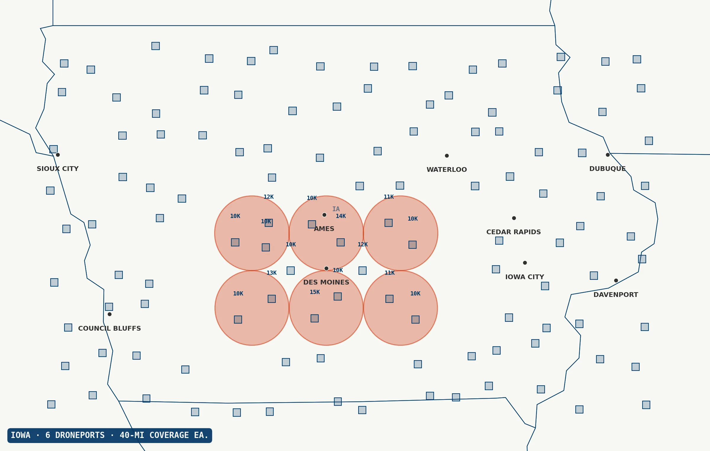
Large-acreage, high-value decisions: variable-rate prescription mapping, insurance loss adjustment across regions, forestry carbon inventory, and precision irrigation planning. The combined range-plus-payload profile turns a week of logistics into a single sortie.
Sensor stacking and specialty instruments.
Typical ag drones carry a single multispectral camera or an RGB system. The Droneforce™ 55 flies pro-grade multi-sensor loadouts — including specialty instruments most drones can’t carry — configurable per mission, with multiple sensors on a single sortie. LiDAR for canopy structure plus a multispectral payload on the same flight gives fused 3D and spectral datasets in one pass. Multiple flight days collapse into one mission. Datasets that used to require research-grade flight economics become routine capture.
Across every alternative.
- vs. satellites Higher resolution, on-demand tasking, cloud-penetrating thermal and LiDAR.
- vs. manned aircraft Whole-farm coverage in one mission, emissions-free, no pilot scheduling.
- vs. standard ag multirotors Orders of magnitude more coverage per flight and richer simultaneous sensor fusion.
- vs. fixed-wing mapping drones Comparable range but much greater sensor flexibility from the payload capacity.
Whole-farm data at crop-calendar cadence.
Data from a networked Droneforce™ fleet, integrated with the systems you already run — keyed to the assets you already manage, delivered into the tools your operations team already uses.
Multispectral, thermal, LiDAR, and specialty-sensor data at whole-farm scale — AI/ML-processed on-board, streamed via Droneforce One’s API into your precision-ag analytics stack. Ready for ingest by variable-rate prescription, crop-modeling, and yield-forecasting platforms operators already run.
Looking for one precision-ag launch partner.
Large-block acreage, season-long temporal stacks, multispectral-driven agronomic workflows. Partners get front-of-line access to the first operational aircraft, direct influence over mission profiles, and the reference-case position as we expand.
Think your operation fits?
Short application. Discovery conversation. If it’s a fit, you’re on the manifest.
AUVSI XPONENTIAL · Detroit · May 2026
Tell us what you need to fly.
Operators, integrators, investors, and DoD program officers route through different inboxes. Choose your lane and we’ll respond within one business day.
